
 企业认证
担保交易
企业认证
担保交易
商品二维码

扫码购买及分享
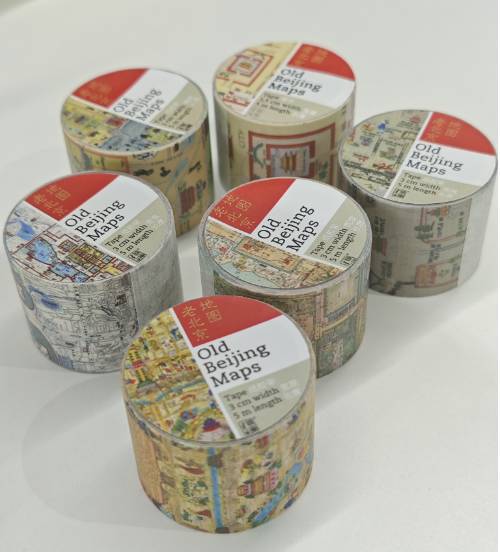
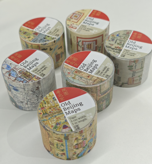
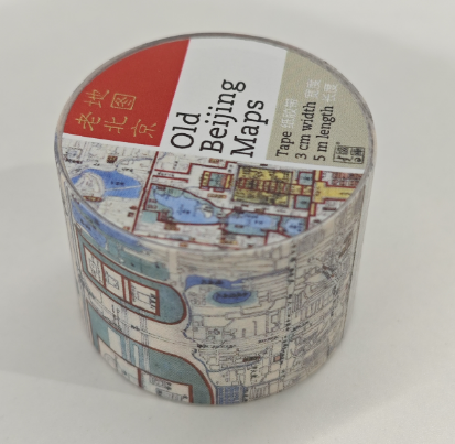
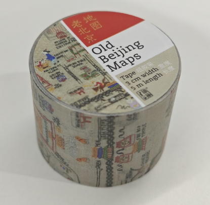
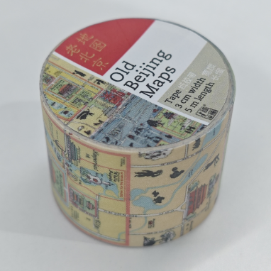
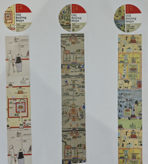
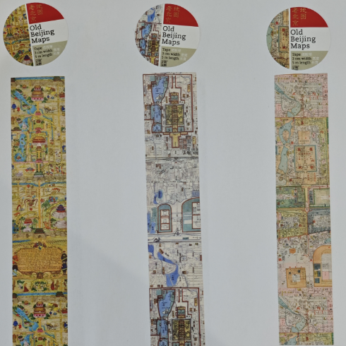
Tape纸胶带——老北京地图(共6款)
价格 : ¥ 20
邮费 : ¥13.00 满 ¥300 包邮
纸胶带 : 北平风俗地图1936年 老北京地图 荷兰大使逛北京 北京地里全图 老北京福利地图 北平内城街道(剪影版)
数量 : -1+ 库存 : 28 销量 : 2
Tape纸胶带——老北京地图(共6款)
¥ 20.00
销量 : 2
邮费: ¥13.00 满 ¥300 包邮
浏览 : 263
商品详情
商品评价
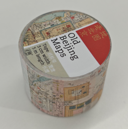
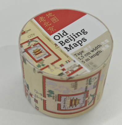
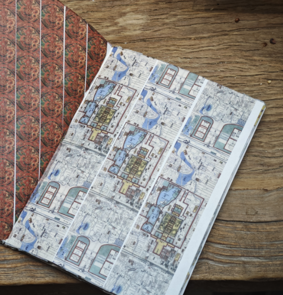
纸胶带,长度5米,宽度3厘米
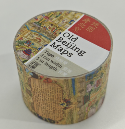
A Map and History of Peiping(北平历史地图) (1936)
民国二十五年( 1936) ,(美)FRANK DORN(弗兰克•窦尔恩)绘,
PEIYANGPRESS,LTD. ,TIENTSIN-PEIPING(北洋印字馆) 。81cm × 70cm, 彩色, 比例尺1:155000,英文。
此图所绘为北平历史 、地理概况 。展现民国年间北京的城市景观 、风俗民情等。 上侧及右侧, 图绘公元前1100年至国民政府迁都南京的北京城建城史,下侧图绘北京婚礼和葬礼的民俗画 。另附说明册,简要介绍北平历史。
此图是民国年间外国人所绘北京城市地图中较有特色的一幅,既形象生动又幽默 风趣。
A Map and History of Peiping (1936)
In the 25th year of the Republic of China (1936), Frank Dorn (USA),
PEIYANGPRESS, LTD., TIENTSIN-PEIPING (Beiyang Printing House). 81cm × 70cm, color, scale 1:155000, English.
This map depicts the history and geography of Peiping. It shows the urban landscape, customs and folk customs of Beijing during the Republic of China. The upper and right sides depict the history of Beijing's city construction from 1100 BC to the relocation of the National Government to Nanjing, and the lower side depicts folk paintings of Beijing weddings and funerals. An explanatory booklet is also included to briefly introduce the history of Peiping.
This map is a more distinctive map of Beijing drawn by foreigners during the Republic of China. It is both vivid and humorous.
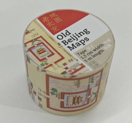
皮姆先生逛北京漫画地图 (1934)
荷兰大使夫人镜头里的民国世相 1934年民国时期,荷兰驻华大使的夫人爱伦·凯 特林(Ellen Catleen,后更名 Ellen Thorbecke 爱伦·托尔贝克)女士拍摄了大量老北京的风光 、民俗照片。她遴选部分照片,配以适量文字,并由奥地利籍著 名犹太漫画家费里德里希·希夫(F.H.Schiff)绘制滑稽漫画,编成一册结合优秀摄 影作品和风趣漫画的旧京图集,于1934年在上海出版 。 书中通过虚构人物皮姆先生(Mr.Pim)及导游吴先生(Mr.Wu)的游览,再现了当时祥和 、安静的北京城及北京人的生活 。 随后作者以Ellen Thorbecke的名字出版了系列与中国相关的摄影书籍,包括上海,香港。
Mr. Pim's Beijing Tour Cartoon Map (1934)
The Republic of China through the lens of the wife of the Dutch ambassador in 1934, during the Republic of China period, Ms. Ellen Catleen (later renamed Ellen Thorbecke), took a large number of photos of the scenery and folk customs of old Beijing. She selected some photos, added appropriate text, and asked the famous Austrian Jewish cartoonist Friedrich Schiff to draw funny cartoons, and compiled them into a collection of old Beijing pictures that combined excellent photographs and funny cartoons. It was published in Shanghai in 1934. The book reproduces the peaceful and quiet Beijing city and the life of Beijingers at that time through the tour of the fictional character Mr. Pim and the tour guide Mr. Wu. Later, the author published a series of photography books related to China under the name of Ellen Thorbecke, including Shanghai and Hong Kong.
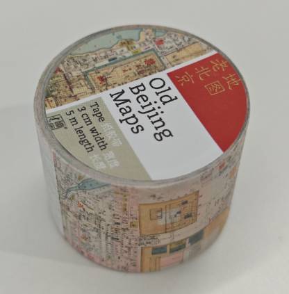
北京地里全图 (1865)
清同治四年( 1865),(清)周培春画 。 110cm ×75cm,彩色。
此图所绘为北京地理概况 。标注东南西北方位,对皇城内建筑有较详细的标识, 绘制有双黄寺、地坛、月坛、东岳庙等坛庙和外国人的墓地。偶有同音异形字的标注,如“其化门大街”“路米仓”等,将广安门写作“彰义门”、右安门写作“西南门”, 左安门写作“将擦门”等。
Complete Beijing Map (1865)
Painted by Zhou Peichun in the fourth year of the Tongzhi reign during the Qing Dynasty (1865). 110cm × 75cm, color.
This map depicts the geographical overview of Beijing. The directions of east, south, west and north are marked, and the buildings in the imperial city are marked in detail. Temples such as Shuanghuang Temple, Ditan Temple, Yuetan Temple, Dongyue Temple and foreigners' cemeteries are drawn. Occasionally, there are homophones and variant forms of characters, such as "Qihuamen Street" and "Lu Mi Cang". Guang'anmen is written as "Zhangyimen", You'anmen is written as "Xinanmen", and Zuo'anmen is written as "Jiangchamen"
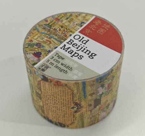
旧京地图品类繁多,Welfare map of Peiping: Also showing other points of interest (1920)
现存最早的一张老北京风俗地图,是1920年一位名为阿特伯里的美国人所绘制的,地图的主题名为福利地图,地图中描绘了大量宗教建筑 、学校 、 医院等西方社会团体在教育医疗卫生领域对北京的贡献, 如图中描绘有北京大学 、国家书馆、西什库教堂、北京道济医院、妇产医院。
Welfare map of Peiping: Also showing other points of interest (1920)
The earliest existing map of old Beijing customs was drawn by an American named Atterbury in 1920. The theme of the map is called “Welfare Map”. The map depicts a large number of religious buildings, schools, hospitals and other Western social groups' contributions to Beijing in the fields of education, medical care and health. The map depicts Peking University, the National Library, the Church of the Saviour, the Beijing Douw Hospital for Women and Children, and the Maternity Hospital.
Peking 北京 (1912-1949)
民国年间( 1912—1949),[美]John Kirk Sewall(约翰•柯克•苏厄尔)绘制,Peiyang Press(北洋印字馆)出版 。60cm×50cm,彩色,中 、英文。
此图所绘为北京内外城历史地理概况。皇城 、内城和外城以不同颜色区分。标注 主要道路、河流,代表性建筑等,侧重于对景点、车站、戏楼和商业街道等的标注。配以大量彩绘及剪影画展现北京城市景观 、民生百态、市井民俗等,直观体 现当时的社会风情。
Peking 北京 (1912-1949)
During the Republic of China (1912-1949), drawn by John Kirk Sewall, published by Peiyang Press. 60cm×50cm, color, Chinese and English.
This map shows the historical and geographical overview of Beijing's inner and outer cities. The imperial city, inner city and outer city are distinguished by different colors. The main roads, rivers, representative buildings, etc. are marked, with emphasis on the marking of scenic spots, stations, theaters and commercial streets. A large number of colored paintings and silhouettes are used to show Beijing's urban landscape, people's livelihood, market customs, etc., which directly reflects the social customs at that time.

店铺信息:
地址:北京市西城区杨梅竹斜街26号乾坤空间
邮编:100051
联系人:贾老师
电话:18611609968
 加入购物车
加入购物车
www.yoopay.cn

长按二维码,然后选择“识别图中二维码” 来关注友付,获得更多活动信息
400.0697.118
service@yoopay.cn

请到移动端个人中心查看
www.yoopay.cn
400.0697.118

这个商品很赞,我要晒到朋友圈!

微信扫码 生成专属邀请函
这个商品很赞,我要晒到朋友圈!
微信扫码 生成专属邀请函
微信公众号

 18611609968
 598278736@qq.com

微信扫一扫,参加拼团


 私信
私信


